File:Emirates Stadium, Highbury and its surrounds from the air.jpg
(Redirected from File:Emirates aerial.jpg)
No higher resolution available.
Emirates_Stadium,_Highbury_and_its_surrounds_from_the_air.jpg (640 × 458 pixels, file size: 140 KB, MIME type: image/jpeg)
Captions
Captions
Add a one-line explanation of what this file represents
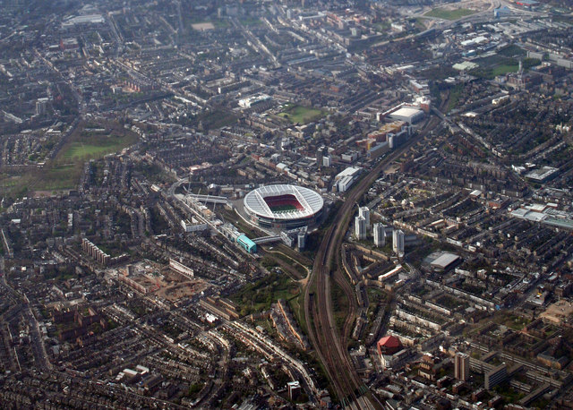
| Description | An aerial view of the Emirates Stadium. The demolition of the former Highbury ground can also be seen to the left of the new structure. |
| Date | |
| Source | From geograph.org.uk |
| Author | Peter McDermott |
| Permission (Reusing this file) |
Creative Commons Attribution Share-alike license 2.0 |
| Attribution (required by the license) | Peter McDermott / Emirates Stadium / |
| Camera location | | View this and other nearby images on: OpenStreetMap |
|---|

|
This image was taken from the Geograph project collection. See this photograph's page on the Geograph website for the photographer's contact details. The copyright on this image is owned by Peter McDermott and is licensed for reuse under the Creative Commons Attribution-ShareAlike 2.0 license.
|
This file is licensed under the Creative Commons Attribution-Share Alike 2.0 Generic license.
Attribution: Peter McDermott
- You are free:
- to share – to copy, distribute and transmit the work
- to remix – to adapt the work
- Under the following conditions:
- attribution – You must give appropriate credit, provide a link to the license, and indicate if changes were made. You may do so in any reasonable manner, but not in any way that suggests the licensor endorses you or your use.
- share alike – If you remix, transform, or build upon the material, you must distribute your contributions under the same or compatible license as the original.
| Annotations | This image is annotated: View the annotations at Commons |
File history
Click on a date/time to view the file as it appeared at that time.
| Date/Time | Thumbnail | Dimensions | User | Comment | |
|---|---|---|---|---|---|
| current | 17:10, 19 February 2009 | | 640 × 458 (140 KB) | Nanonic (talk | contribs) | {{Information |Description=An aerial view of the Emirates Stadium. The demolition of the former Highbury ground can also be seen to the left of the new structure. |Source=From [http://www.geograph.org.uk/ |
You cannot overwrite this file.
File usage on Commons
The following 2 pages use this file:
- File:Emirates Stadium, Highbury and its surrounds from the air (2007).jpg (file redirect)
- File:Emirates aerial.jpg (file redirect)
.jpg&redirect=no)
File usage on other wikis
The following other wikis use this file:
- Usage on az.wikipedia.org
- Usage on cs.wikipedia.org
- Usage on en.wikipedia.org
- Usage on eu.wikipedia.org
- Usage on fr.wikipedia.org
- Usage on id.wikipedia.org
- Usage on my.wikipedia.org
- Usage on sv.wikipedia.org
- Usage on zh.wikipedia.org